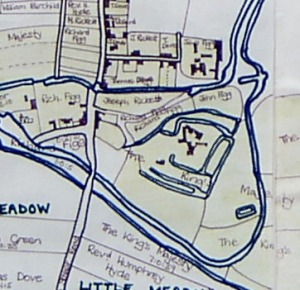
The route of the Navigation through West Deeping
The Commission of Sewers which met in 1620 and the subsequent grant of James I (1623) “Respecting the making the River Navigable” , which allowed the Aldermen and Burgesses of Stamford to construct the “New Cut”, tell us precisely the route the commissioners proposed the canal should take:
”through and along the same ditch or drain to the fields and meadows of West Deeping, and onwards still and along the same drain or ditch to an old stone bridge in the town of West Deeping, and from thence still along the said ditch or drain to another highway on the east side of the said town over against the house of one Charles Weldon and from thence into another old ditch dividing the fields of West Deeping, and a little lane leading to Market Deeping, until it come to the highway that leadeth from Tallington to Market Deeping, and from thence on the south side of the said way to Market Deeping corn mill.”
(Quoted in Antiquities of Stamford and St Martins (1785) William Harrod; Stamford Town Hall, Tebbut Library T65 and in The History of Stamford (1822) John Drakard)
We have not found any sufficiently detailed maps pre-dating the construction of the canal, so it is not known for sure that the route proposed in 1620 was actually followed. The 1813 Enclosure Award map is the first map with a large enough scale to see the route in relation to features and buildings we can recognise. (The Parish Chest copy of the map has been lost since the drawing was made, but a copy can be seen at Lincolnshire Archives, reference Kesteven Award 24 West Deeping)
.
For further details about the canal’s route through the parish of West Deeping select from the list below:
- The ‘Boaty’
- King Street Crossing
- Molecey’s Mill (in preparation)
- West Deeping locks: 4 Molecey’s/ 5 Lammas Close / 6 ‘St Andrews Lodge’
- Winding holes
- West Deeping buildings

